Intranational International Boulevard: A Street's Atlas
This project has ended, but you can still support amazing Berkeley initiatives by visiting give.berkeley.edu. Your continued support of our students, faculty and staff will ensure that Berkeley remains the #1 public university. Go Bears!
We are the CAGE Lab, UC Berkeley’s Cartography and GIS Education Lab, in the Department of Geography.
We’re at it again! Mapping communities at a hyper-local scale and compiling the maps into an atlas. Our last project, Mission Possible: A Neighborhood Atlas, was published in 2012, and can be viewed at missionpossiblesf.org.
Our current project is titled Intranational International Boulevard. International Boulevard is a major thoroughfare that spans 107 blocks of Oakland, from downtown to the border of San Leandro and runs through the neighborhoods of Eastlake, San Antonio, The Fruitvale, and East Oakland. The atlas project endeavors to create a holistic picture of place and uncover the alternative narratives that may run counter to the historically uni-dimensional reputation of East Oakland.
"Stories matter. Many stories matter. Stories have been used to dispossess and to malign, but stories can also be used to empower and to humanize. Stories can break the dignity of a people, but stories can also repair that broken dignity. When we reject the single story, when we realize that there is never a single story about any place, we regain a kind of paradise." - Chimamanda Ngozi Adichie
We’ve already created more than twenty maps, including such things as the diversity of churches, the density of public art, the ethnic identity of sweet shops, Taco Trucks of East Oakland, and much more. We’re also mapping some of the more challenging aspects of this community like the abundance of check-cashing businesses and the lack of banks, the value of land and the density of trees with the prevalence of childhood asthma. See the bottom of the page for the current list of maps that are completed and those in production.
This is a project of experiential learning—our cartographers go into the field to collect data and to taste the experience of East Oakland. We’re seeking collaboration with community leaders and you, too! You can get involved by supporting the project through your donation. We’ll thank you by adding your name to the book as a contributor and putting you on the contributor’s map—you don’t need to live in Oakland to be mapped—that map will be the scale of our reach.
The CAGE Lab will make these maps and compile the atlas even without UC Berkeley’s exciting new crowdfunding platform. But to get it published and printed is where crowdfunding can play an important role. Help us make this project a material artifact that can be shared with the larger community. If we can raise enough money, we will print the atlas in beautiful full-color to create a volume you can hold in your hands. We will make the atlas available for sale at low cost and have planned a special surprise thank you for everyone who contributes. We’re committed to the Oakland community and so we will print and bind it locally. And, the money we raise can pay for more than just the printing. Once we cover the cost of printing, we will provide modest stipends to the cartographers and researchers and the generous videographer who made our video.
We have some special perks for those that want to join the mapping effort. We’re looking for people who want to help us locate all the pink houses in these neighborhoods for the Pink Houses Project and people who want to work on the Language of Signage map. This is a map that records the diversity of language used in business signage so that a broad view of the diversity of East Oakland created by the people who live and work in the community can be understood.
Besides the exciting fieldwork opportunities and getting your name in the atlas, we have other awesome perks in the works: meet the team and get your purchased copy of the atlas signed, join us on a taco tour, and have atlases donated in your name to schools and libraries.
By reaching our goal, we will also be able to make the project more accessible by creating a web interface to host the data and allow mash-ups so you can create your own maps of International Boulevard. And, if we can raise more than our goal, we will be able to print and donate more atlases.
The complete atlas team includes: Darin Jensen, Sasha Helton, Cooper Krings, Jake Rosen, Sierra Willems, Zach Loran, Mark Hickok, Bridget Smith, Madison Kausen, Ellie Broadman, Tabitha Hewitt, Lauren Guzman, Annaliese Ng, Maia Wachtel, Daniel Contreras, Julie Sadlier, Jong Lee, Eron Budi, Annaleigh Yahata, Carrie Huang, Kimberly Becerril, Brittany Burson, Marcea Ennamorato, Madeena Siddiqui, Selena Feliciano, Nima Sinclair, and Nica Powell.
Let’s make Intranational International Boulevard an incredible atlas together!
Current list of maps:
International Food Oasis (Culturally-identified groceries and distance to transit)
Breathe in International Boulevard (Childhood asthma and the Oakland tree census)
The International Language of Sugar (The cultural identity of sweets shops)
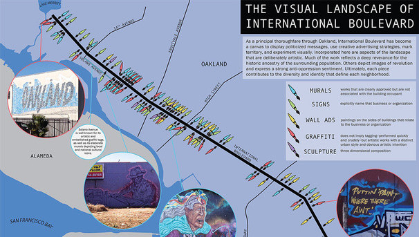
The Visual Landscape of International Boulevard (Sanctioned and unsanctioned public art)
Places to Play (Site suitability analysis for where to build a playground)
Trash vs. Cans on International Boulevard (The density of litter and garbage cans)
From Creeks to Culverts: The Vanishing Waters
AC Bus Stops (Infrastructure and Condition)
Road to Remittances (Check-cashing businesses and banks)
International Boulevard Automotive Commerce (Automotive-related businesses)
The Legal and Illegal Sale of Beauty (Beauty shops and other sales of beauty)
The Internationality of Religion (Nineteen categories of houses of worship)
Education...Educación… (Public and private schools and percent of population with high school diploma)
Neighborhoods of International Boulevard (The City of Oakland’s Neighborhood Map)
The Cost of Owning International Boulevard (Property values and median household income)
Intranational International Affordable Housing (Affordable Housing and annual median income)
List of maps in progress:
Mien People (The Mien community)
Historical International Boulevard (What was here before)
Chain stores and small businesses (densities)
Community Health Care (sites and types of services)
Diabetes and Retail Food Environment Index)
AC Transit’s BRT (Bus Rapid Transit) Plan
Pink Houses
Taco Trucks of East Oakland
$15
Collaborator
Named collaborator in the published atlas and your location on the collaborator's map. PLUS all perks below this level.
$25
Map Groupie
Meet the team at an exclusive launch party and get your *purchased* atlas signed. PLUS all perks below this level.
$50
Mentor
We will donate two atlases to schools in the International Boulevard Corridor PLUS all perks below this level.
$100
Teacher
We will donate five atlases to schools or libraries in the International Boulevard Corridor PLUS all perks below this level.
$200
Librarian
We will donate ten atlases to libraries in the International Boulevard Corridor PLUS all perks below the Teacher level.
$300
Surveyor
Join our team and help us survey the neighborhoods to locate and map all the pink houses PLUS all perks below the Teacher level.
$300
Researcher
Join our team and help us research the Language of Signage along International Boulevard PLUS all perks below the Teacher level.
$750
Cartographer
Join our team and author a map for the atlas. You will spend a day in the CAGE Lab learning how to make a map under the direction of lab staff


